Pages

2.28.2016

A Long Last Drive With An Old Friend: The 2016 Mitsubishi Lancer SEL

Front view of 2016 Mitsubishi Lancer
The 2016 Mitsubishi Lancer.
It's seconds till sundown for the Mitsubishi Lancer.  On the market relatively unchanged for a decade and stripped of its high-performance EVO model, time has caught up with this generation of Mitsu's compact sedan. Still, it is a car not without charms, as we learned to our surprise during a North Coast roadtrip two years ago.


Rear 3/4 view of 2016 Mitsubishi Lancer
2016 Mitsubishi Lancer.
By coincidence, Mitsubishi had scheduled us in the 2016 Lancer SEL AWC for a week that included Valentine's Day and President's Day.  Navigator and I opted for a four-day weekend and went where our story together began, the Mendocino County town of Ukiah (if it rings a bell, The Doobie Brothers did a song about it)...but as always with the two of us, there are adventures along the way.


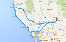
Folsom-Winters-Ukiah-Comptche-Fort Bragg-Bodega-Bolinas-Folsom map
Just your typical TireKicker four-day weekend (Source: Google Maps)
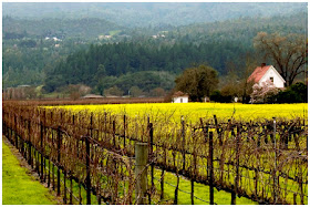
You can get from Folsom to Ukiah in about three hours by simply sticking with U.S. 50, Interstate 5, CA 20 and U.S. 101, and we go that way occasionally.  But it was a glorious mid-winter morning, so we took the scenic route, stopping for a hearty breakfast at the Putah Creek Cafe in Winters, then up Highway 128 through the upper Napa Valley, where the grape leaves have fallen for the winter and have been replaced by an explosion of color from mustard seed:


Napa Valley vineyard with mustard
Napa Valley mustard.
After a day in Ukiah, it was on to Fort Bragg and Mendocino for the next two days and nights.


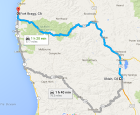
Ukiah Fort Bragg Map
Two ways to get to the coast from Ukiah. (Source: Google Maps)
  
If you ask Google Maps (and most people), there are two ways to make that trip.  One is to take U.S. 101 north out of town to Willits and then go west on CA 20 to the Pacific.  The other (which Navigator and I prefer) is to take State Street to the south end of town, then go west on CA 253 to pick up CA 128 (the road that runs through the northern Napa Valley) and drive through the beautiful Anderson Valley, which is not only scenic, but home to a wonderful roadside apple stand and some terrific small wineries and craft brewers.

But there's a third way, which neither of us had ever taken.  If you look between the two recommended routes on the map above, you'll see a faint gray line with no highway number passing through Montgomery, Comptche and Melbourne and coming out just north of Little River.  Just north of Ukiah, that road starts as Orr Springs Road.  At Comptche (population 159), it becomes the Comptche-Ukiah Trail.  We took that.  And within minutes, we saw this:
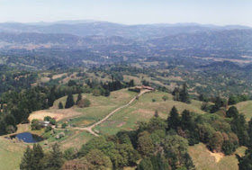

View of Ukiah from Orr Springs Road
Ukiah from Orr Springs Road
The road climbs quickly and in five minutes, you have a commanding view of the entire valley.  What's ahead through the windshield is arguably even better:


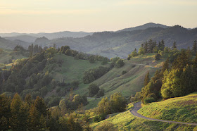
Orr Springs Road looking west
West on Orr Springs Road to the Pacific.
Gorgeous, right?  And it's like that all the way to the Pacific Ocean, save the final 20 minutes or so as you drive through deep redwood forests.   A tight little two-lane, well-maintained but narrow enough as to be unmarked in stretches.

The Lancer, which has All-Wheel-Control that can be switched between two-wheel and four-wheel drive, simply ate it up.  

Fort Bragg and Mendocino (which also has a pop song about it) may only be ten miles from one another on the same road (California's world-renowned Highway 1), but they are as different as night and day.  Fort Bragg is bigger (7,250 people to Mendocino's 894) and has a funky vibe that is in sync with its past as a rough-and-tumble logging and fishing town.  
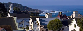

Mendocino, California
Mendocino, California.
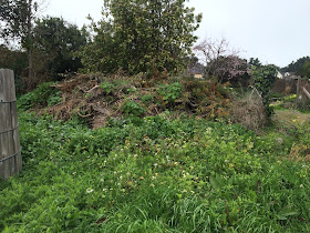
Mendocino is just heaven.  As Navigator says, even the trash piles are beautiful. 


Trash pile in Mendocino
A Mendocino trash pile.
There simply isn't a bad view in town.


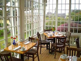
The Grey Whale Bar at the MacCallum House Hotel
The Grey Whale Bar at the MacCallum House Hotel.
Take, for example, the MacCallum House Hotel, where Navigator and I make it a point to have dinner at least once each visit.  That picture above is where you sit if they ask if you'd like to eat in the bar.  It beats the dining room hands down, because those big, beautiful windows look out on the Pacific Ocean (two blocks away) and you can watch the most spectacular sunsets imaginable. 

For the trip home, Navigator and I chose another untried route...Highway 1 all the way down into Marin County...the only bit of Highway 1 I hadn't driven yet.  We took our time.  So much so that at the end of five hours of driving up a clearly-marked dead end road leading up into the hills above Albion just to see where it ended up, hiking down to and strolling on the beach at Elk, and other meanderings, we'd covered only 50 miles.

Which brings us to Bowling Ball Beach.
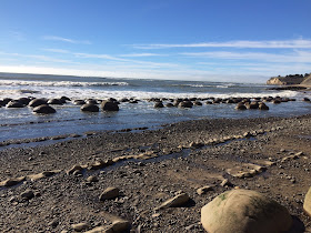

Bowling Ball Beach
Bowling Ball Beach.
Navigator and I had wanted to go since seeing pictures online.  The guidebooks say it's in Gualala (pronounced wa-LA-la).  The guidebooks lie.  It is, in fact, just south of Point Arena, which is 11 miles north of Gualala, which we learned after traveling the 11 miles south to Gualala. It is also unmarked, at least by the name "Bowling Ball Beach".  What you're looking for is Schooner Gulch.  There'll be a bunch of cars parked along the side of the road for no obvious reason.  And there'll be a trail along those cars.  Take that for about half a mile, hike down a hill followed by Mother Nature's own Marine Corps obstacle course and you're there.  It's remarkable.  More impressive at low tide, when the rocks are completely out of the water, but still.

After that, the pressure was on to get moving.  The goal, Bolinas by sundown.  More on that in a moment, but first, a glimpse of the some of the 104 miles ahead:

Jenner Grade, Highway 1
Jenner Grade, Highway 1.
This is some of the most amazing road on earth.  Twisting, turning...away from and then toward the sea, sheer cliffs with no guard rails.  Exhilarating...and more than a little terrifying.  The last time I took Jenner Grade was in a Toyota Avalon Hybrid, which dealt with it well when I turned the optional active suspension to "sport".  Still, it was a big car without much room for error on those narrow curves, and we took CA 116 inland to Santa Rosa rather than continue on Highway 1 all the way down.

The Lancer SEL was the right size and, switching to AWD/AWC, felt perfectly planted on the seemingly endless curves.

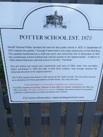
God's own Formula 1 course safely navigated, we arrived in Bodega Bay, a place movie buffs will remember as the town in Alfred Hitchcock's 1963 movie "The Birds".  The scene everyone remembers is when the flock of crows attacks schoolchildren as they flee their beautiful old schoolhouse. 


Navigator and I had never been to Bodega Bay, and are big Hitchcock fans, so we kept our eyes peeled for the building...but never saw it.  What we did see, just out of town, was a road with a sign pointing to "Bodega", five miles inland.  

We were racing the sun, but heck, yes, we took it.  And found the schoolhouse:
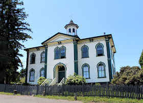

Bodega Schoolhouse
Potter School, Bodega, CA.

Potter School sign
The real story of the real schoolhouse.
And now, we know the rest of the story.  Perhaps the only stranger story than a flock of birds taking over a town would be a California beach city that doesn't want to be found.  And that's the story of Bolinas.  


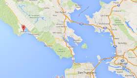
Bolinas map
Bolinas and its place in the universe (assuming the universe is the Bay Area, which is not an uncommon assumption around those parts).
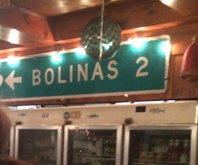
Bolinas, you see, is steadfastly anti-development, anti-growth and anti-tourism.  So much so that everytime CalTrans, the state transportation department, would post a sign for the turnoff to Bolinas along Highway 1, the locals would take it down.  Not just once, but, according to a 1989 Los Angeles Times story, 36 times in 20 years.  GPS navigation in cars has rendered it all rather moot (you can find anyplace by entering its name, address or coordinates) but our Mitsubishi Lancer SEL didn't have GPS, so we found our way (with the help of a loose-lipped bartender up north a ways) in the dark (we lost the sun along Drake's Bay)...like good old-fashioned pioneers. Or detectives. Or something.  Whatever, we get cred.


CalTrans highway sign on wall of Coast Cafe
CalTrans highway sign on the wall of the Coast Cafe.
Not sure about the other 35, but one of the CalTrans signs adorns the wall of the Coast Cafe, Bolinas' only restaurant, closed on Monday nights, where we enjoyed a wonderful meal...on a Monday night.  It's a charity deal that we literally stumbled into---local chefs preparing locally caught and locally grown food---and the folks of Bolinas, with whom we dined at communal tables, couldn't have been nicer.


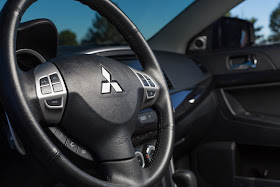
Interior view of 2016 Mitsubishi Lancer
2016 Mitsubishi Lancer interior.
And with that, it was back behind the wheel of the Lancer for the trip back to Folsom, down Highway 1 though Stinson Beach, along the edge of Mt. Tamalpais State Park and in between Muir Woods National Monument and the Marin Headlands into sudden Marin County suburbia, then on to U.S. 101 north to Novato and Highway 37 eastbound to I-80 and home (don't do what I did and shoot for the Richmond-San Rafael Bridge...trying to hit eastbound I-80 is confusing and frustrating).

The EPA says the Lancer is good for 23 miles per gallon in the city and 31 on the highway.  We saw 26.9, but let's face it, 25 miles an hour on twisting roads above the sea is not what the EPA means by "highway driving". 

For $21,995, the SEL AWC comes with the aforementioned all-wheel drive and all-wheel control, as well as halogen headlights, LED running lights, fog lights (which we used more than once and which illuminate the pavement brilliantly in very low-visibility conditions), 16-inch alloy wheels, heated front seats of which the driver's is an eight-way adjustable unit and the passenger's four-way, a 60/40 folding rear seat, automatic climate control, rearview camera and a 140-watt audio system with SiriusXM and HD Radio which, although it is iPod capable, is enormously frustrating...long waits for your library to load, lost places in playlists....frankly, it was maddening.  Hopefully, in the all-new 2017 Lancer, state-of-the art audio interfaces will be part of the standard equipment.

All in all, though, the iPod interface was my only real complaint in a four-day, 500-mile roadtrip. Even with its advancing age, at $22,805 with destination and handling charges, the 2016 Mitsubishi Lancer SEL is a strong value for the money.  

NOTE: None of the businesses mentioned in this review know me or knew I would be writing about them.  They're simply mentioned because we enjoy them and think you might too.